A.5. Condition Bio - Physical Kalimantan Island
A.5.1. Bio-geography
Separation between Borneo and Sulawesi fauna initially known by the great explorers and nature lovers 19th century, Alfred Russel Wallace, who spent nine years to explore Indonesian archipelago. He proposed a limit of Asian fauna, namely Bali and Lombok to the north through the Makassar Strait between Sulawesi and Borneo, including the Philippines. Then Thomas Huxley, a biologist, reducing the Wallace line by releasing all the Philippines except Palawan, which follow the boundaries of the Sunda Strait and covers the entire continent of Sunda Konu. Although there is debate about its validity, the Wallace Line is now a good guide as a useful barrier to the distribution of many genera of animals and plants (Balgooy 1987; Goerge 1987) [1]
Biogeographic units in Borneo
The spread of animal and plant species in Borneo are not uniform. In addition to a clear distribution according to altitude and habitat boundaries, there are differences in the division fitogeografis, which may reflect the different geographical history, land relations Kala Pleistocene and geographical barriers that impede the spread of species. Borneo and the islands off its coast can be divided into 9 units biography (MacKinnon and MacKinnon 1986 with seven units on the island of Borneo saja1.
The spread of flora, the location of plant richness and endemism in G. Meratus in South Kalimantan and north coast including the eastern Berunai and Sarawak, both renowned for its rich tumbuhannya species (Myers 1988). Into four different Boiunit diperbukitan konu centered southwest of Borneo, north of S. Kapuas and Sarawak the west. Lowlands in the south, a forested area of peat swamp and freshwater marsh area, generally fewer species richness. East coast of Borneo is somewhat different because of the dry musimanlebih other than the pilau. Regions that are less known and distinctive covers the hills and mountains of central Borneo that have not been in eksploitasi.1
Distribution of fauna are not only related to the type of habitat but also the geographic barriers such as mountain ranges and rivers. Borneo lowland region drained by the river - the main river, which acts as a barrier width displacement animals. Upstream the river, where these rivers and its tributaries more narrow and fast flowing but it is generally easier on the cross, located at the upper limit of distribution according to altitude for the lowland species. The rivers Kapuas and Barito act as a barrier to separate the endemic fauna of Borneo dn migrants who reach Borneo from Sumatra in the late Pleistocene Kala, when Sumatra and West Kalimantan are still connected by land. 1
A.5.2 Keep. Climate
Borneo is located at the equator and has a tropical climate with a relatively constant temperature throughout the year, ie between 250 -35 0 C in the lowlands. Vegetation type is not only determined by the amount of annual rainfall also by the distribution of rainfall throughout the year. Lowlands along the equator that have a minimum of 60 mm rainfall every month to support evergreen forest (Holdridge 1967). All of the Borneo is located in an area that is always wet all tahun.1
The pattern of rainfall in Indonesia is determined by two monsoons - the southeast monsoon or "dry season" (May - October) and northwest monsoon or "wet season" (November - April). From May to October the sun across Indochina and southern China, and a belt with a low pressure develops over the Asian mainland is hot. The wind that brings rain blowing northward from areas of high pressure over Australia and the Indian Ocean. These winds absorb moisture while crossing a vast ocean. When we reach the islands of the Greater Sunda region and mainland Asia, the wind rose to the top because they have to cross the line of hills and mountains. While rising air becomes cooler and the humidity drops to the point of rain. Very heavy rains fell over southern India and China and lower rainfall fell on the shallow Sunda islands including Borneo.1
From October to March the sun across the south of the equator. Central Asia is very cold and hot areas of low pressure sekarangberada in the southern continent of Australia. Monsoon which blows from areas of high pressure over the Indian ocean. In place of hot air meets cold danudara, heavy rain occurred over the entire shallow Sunda and Sulawesi, Nusa Tenggara and P. Irian.1
Borneo is located in the line of the Equator and has a tropical climate with a relatively constant temperature throughout the year between 250-350 C in the lowlands. Lowlands along the equator that have a minimum of 60 mm rainfall each month to support evergreen forest. Borneo is located in wet areas throughout the year [2]. Having at least wet month with rainfall less than 200 mm. Northwest monsoon (November-April) are generally wetter than the south-east monsoon, but some coastal areas showed bimodal rainfall pattern. Kalimantan can be divided into five agro-climatic zones. Most of the area high perbukitanyang receive rainfall 2000-4000 mm per year. Large parts of Borneo into the wettest area (Oldeman et al. 1980). Not like Sumatra, Kalimantan there are no mountains in the coastal areas which affect the rainfall, although some short mountain affect local rainfall, especially in eastern Borneo. Central and western Borneo is the wettest area, while the parts on the east coast is much more kering1. West Kalimantan and Central Kalimantan is the wettest region. North-west monsoon in West Kalimantan in August-September and the rainy season lasts until May. Rainfall is very high, especially in November and the second in April. In the month of June to August are relatively dry climate, but there was no moon that rainfall of less than 100 mm. Annual rainfall in Putussibau (Kapuas Hulu) reached more than 4000 mm and no month rainfall less than 200 mm. With all year hot areas and areas lembab2
Northwest monsoon reached West Kalimantan in August-September and the rainy season lasts until May, rainfall is very high, especially in November and the second in April. From June to August, the climate is relatively dry but there was no moon that rainfall of less than 100 mm. Rainfall in Putusibau more than 4,000 mm and no month rainfall less than 200 mm. In Central Kalimantan and South, generally getting higher rainfall to the north of the coastal areas. Southeast monsoon influence is much greater than in West Kalimantan. Dry months occur from July to September, especially in areas of rain shadow in the western part Meratus Mountains, for example in Martapura. But the dry season here still do not fuse in Java and Nusa Tenggara. Coast in the southeast and P. Sea is generally wetter than the south coast. Because of the influence of Mount Meratus (Oldeman et al 1980) 1.
Coastal areas in East Kalimantan and the eastern part Sanah much drier than other parts of Borneo. Effect of the northwest monsoon is much weaker because almost all rain falls in the central mountains. Even during the rainy season, rainfall is relatively low and seringkurang of 200 mm / month, especially in areas Sankulirang Peninsula. There is no specific dry season because of seasonal wind southeast across the open sea, so also bring rain to the area lain1.
Although the general pattern of Borneo climate characterized by high rainfall, short dry periods throughout the year play an important role in plant life and affect the patterns of flowering and fruiting in plants. Only an occasional dry season lasts a bit longer. In the years 1982-1983 in Borneo there are prolonged dry season, which happened again in 1987, 1990 and 1997. This long dry season which occurs periodically in the history of Borneo, and possibly associated with El Nino oscillation in the south (Leighton and Wirawan 1986) .
Box: Climate Conditions Provincial Per-
South Kalimantan:
· Average temperature ranges from 15.6 oC to 26.9 oC. while the average humidity ranges from 77% - 91% every month.
· Average highest rainfall of this area occurred in March of approximately 426.0 mm and the lowest occurred in September is approximately 75.0 mm
· Rainfall in Peg. Meratus and the East Coast average of 2000-3000 mm, while in the western region and the South Coast Meratus average of 2279-2649 mm.
Central Kalimantan:
Characteristics of climate in Central Kalimantan is the Type of climate: tropical humid and hot. Koppen Classification: Afa. The average air temperature of 29 ° C, maximum 33 ° C. Rainfall annual average: 2732 mm with an average of 120 days of rainy days. Classification of rainfall and Farguson Schmidt: Type - A (Q = 14.3%) and Type B (Q = 33.3%), more to the North the higher rainfall. (KTDA 2004)
West Kalimantan:
Climate of West Kalimantan, including tropical wet and has ± 3,000 mm of rainfall per year and number of rainy days 170 days per year. The air temperature varied between 20.3 º C - 33.3 º C.
East Kalimantan [3]:
Denganmusim dry tropical climates usually occur in May to October, while the rainy season occurs from November to April. This situation was to take place every year interspersed with transitional season in certain months. Because of its location on the equator, the climate by Monsoon winds, namely the West Monsoon winds of November-April and East Monsoon winds from May to October. But in recent years, the state of the season in East Kalimantan sometimes erratic. In the months that should be raining in reality there is no rain at all, or vice versa in the months that should dry season rains occur even with a much longer season.
The temperature was somewhere between the other is determined by the high and low places on the sea surface and its distance from the beach. In general, East Kalimantan region hot climates with air temperatures in 2003 ranged from 17.90 º C (Meteorological Station of the Long Bawan = September) up to 35.60 º C (Meteorological Station Cape Selor = May). The average air temperature at a low of 18.83 º C occurred in Long Bawan and average air temperature high of 34.69 º C occurred at Tanjung Selor. In addition, as a tropical area with a vast forest habitat in East Kalimantan has relatively high humidity with the average ranging from 81.42 to 86.25 per cent. Humidity is lowest that can be monitored through Samarinda Meteorological Station in March amounted to 73.00 percent, the highest being found in Tanjung Redeb Meteorological Station which occurred in December amounted to 89.00 percent. The average minimum and maximum temperature and air humidity average in 2003 at several meteorological observation station.
Rainfall in East Kalimantan area varies according to month and place of observation station. Average highest rainfall during 2003 was recorded at the Meteorological Station at Aberdeen 267.32 mm and the average lowest rainfall was recorded at Station Long Bawan which only reached 122.59 mm. Wind situation in East Kalimantan in 2003 which is monitored at several monitoring stations, shows that wind speeds ranged from 0.70 knots to 8.00 knots. The highest wind speed 8.00 knots occur in the city of Balikpapan in July through September, while the lowest occurred at 0.70 knots Selor Cape Town in December.
|
A.5.3. Bentang Alam
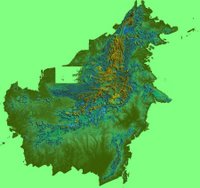 Fig. Formation of Medan on the island of Borneo
Borneo has a flat island, due to having a low and elongated coastal and river plains, especially in the south and west. More than half the island is located at an altitude below 150 m above sea level and tides can reach 100 km to the inland. Borneo has no active volcanoes but the main mountain range originally a volcano. The main chain of mountains through the center of the island like a trident inverted from north to south with three eyes forked spear in the south. Mount Kinabalu in Borneo whose height 4101 m above sea level, is the highest peak in southeast Asia and is the highest mountain between the Himalayas and the snow-capped peaks Jayawijaya in Irian Jaya. Another mountain peak in Borneo which reaches 2,000 m only a few. Mount Kinabalu composed of granite plug which is taken up by volcanic pressure high and still rising.
Mountains of Iran (Iban) between East Kalimantan and East Malaysia rose to 2160 m in G. Aaron (Harden), near the border with Sabah. The tip of the western chain of mountains forming the ranks of central Iran along the Kapuas Hulu in West Kalimantan border with Sarawak. Towering in G. Lawit (1767 m) and G. Cemaru (1681 m). From the central highlands around Mt Cemaru, Muller Mountains (highest peak Mt Liangpran 2240 m) and Schwaner Mountains (Bukit Raya 2278 m) across the border westward along the Central and West Kalimantan. Southeast towards the mountain Meratusyang transverse low (the highest peak of 1892 m Mt), separating the southern and eastern Kalimantan and extends southward along the coast. The whole chain of mountains is a secondary mountain range with an average altitude of 1000-1500 and with only occasional peaks reaching 2,000. Makita Mountain (2987 m) located near Longnawan and G. Giho (2550 m) near Longsaan, both located on the border with Sarawak is the highest peak of Borneo that are in Kalimantan, followed by G. Mantam (2467 m) west of Cape Redep, East Kalimantan.
Borneo tertoreh by large rivers flowing from the center of the island to the coast. Borneo has three longest river that became the pride of Indonesia. S. Kapuas (1143 km), Barito river (900 km) and the Mahakam River (775 m). S. Kapuas flowing from the feet g. Cemaru to the west, running down most of the West. Barito River is big water eyes Muller came from the mountains and flows south and met with the State Rivers originating from Mount Meratus estuary near Banjarmasin. Kahajan small but has a historical significance are also running down the south coast. Kayan River and S. Mahakam flowing from the mountains in the hinterland to the east coast. A number of large river systems that have children who are very wide river in the area of the flow in the interior dam beaches in the lowlands. S. Mahakam, S. Barito, S. State, S. Kapuas and S. Baram (Sarawak) all have a horseshoe lake and seasonal creek in flood plains. In the south, the creek flows into Seruyan Bayan.
BOX:
Landscape one by one Kalimantan province
Topography Kalteng:
1. The south, consisting of coastal areas and swamp and is affected by the tides with the height of 00-50 meters above sea level
2. Middle part, is an area of plains and hilly / wavy with the dominant land cover in the form of a typical tropical rain forest with an altitude of 50-100 meters above sea level
3. Northern part is the hilly and mountainous regions with an altitude above 150 meters asl (Dishut Kalteng 2006)
Most of the province is kaimantan central lowlands, the height ranges from 0 to 150 meters above sea level. Except for a small portion in the north is a hilly area in which Muller and Schwaner mountains lie with highest peak (Mount Raya) reached 2278 meters above sea level dar. (KTDA 2004)
Topography of South Kalimantan:
Regional · flat (slope 0-8%), covering an area of 915,427 hectares or 24.39% of the total land area is spread along the East Coast and South, along the Barito river flow and Other significant rivers.
Regional · ramps (slope of the ground level of 8-15%), covering an area of ± 646,250 ha or 17.22% of the total area that is the area between the mountains Meratus with Sungal Barito, in the west, and the East Coast and the South Coast
· Regional Rather Steep (slope of the ground level 15-25%), covering an area of 1,742,472 ha or ± ± 48.77% and the entire land area that is spread across the east and south near the mountains Meratus
Regional · Steep (slope of the ground level 25-40%), covering an area of ± 88,153 ha, or 2.35% of the land area of existing
· Area is very steep (slope of the ground level above 40%) covering an area of ± 360,750 ha or 9.61% and the whole area available, this area is mountainous Meratus backs and shoulders of the existing rivers
Most areas in South Kalimantan is at a height class 25-100 m above sea level which is 31.29%.
Kalbar Topography:
West Kalimantan Province is a region which has a natural surface that consists of lowlands and highlands. Stretch of lowland along the coast there are from north to south and along the river basin (DAS). Most of exposure to low-lying coastal marsh is a peaty terrain. Plateau and mountainous region located on the east line of Miller and Schwaner Mountains stretching along the border with Central Kalimantan Kapuas Hulu and Mountains along the border with Sarawak (East Malaysia).
Kaltim Topography:
East Kalimantan mainland can not be separated from the mountain chains and mountain contained in almost all districts, namely that there is about 13 mountain. The highest mountain in East Kalimantan, namely Mount Makita with a height of 2987 meters, located in the District Bulungan. As for the lake of about 17 pieces, the whole being in Kutai with the most extensive lake that is Lake Jempang, Semayang Lake, and Lake Across each with an area of 15,000 hectares, 13,000 hectares, and 11,000 hectares.
Altitude 100-500 m above sea level (41%), 500-1000 m above sea level (43%), 1000 (16%)
A.5.4. Land
The soil is an important factor influencing the spread of vegetation. There are five major factors in soil formation: lithology, climate, topography, living beings in time. In general, knowledge about the spread of land in Kalimantan is still limited; 90% of the soil survey report prepared by the Land Research Center is limited to specific projects such as transmigration, plantations or irrigation networks (Sudjadi 1988).
Most land in Borneo has been developed on undulating plains and mountains above tertoreh sedimentary and igneous rocks older. These lands range from Ultisol sour side dish and Inceptisol very young. In the southern alluvial plains and the vast peat lands, continued to expand until the Java Sea. This expansion continues to occur in the shallow southern part of Kalimantan, with alluvial deposits that formed behind the coastal mangroves.
In the humid tropics weathering took place very quickly, due to the heat and humidity. Because of high rainfall, the soil is always wet and basic elements that can dissolve missing; this process is called leaching. The level of weathering, leaching and biological activity (damage organic materials) that is characteristic of various soil high in Borneo (Burnham, 1984). Rock island is poor and metal content of Borneo are generally less fertile soil than the fertile volcanic soils in Java. Perfect weathering accompanied by leaching resulted in soil fertility in many low-lying low. Steeper slopes may be more fertile because of erosion and landslides continue to prove a new source rock.
Land above the main part of central Borneo and northeast Borneo is ultasol (acrisol). Soils have very severe weathering form a kind of red-yellow podzolic soil in most of the mainland of Borneo are bumpy. Most of the Ultisol in Kalimantan is tropodult. Type udult difficult to be used extensively because of lower nutrient content in surface layer composition between the low and high aluminum content and strong acidity (RePPProT 1990). Traditionally local people have used this land for shifting "move" with annual crops and fallow periods are longer in order to recover soil fertility. This method provides an opportunity for the surface layer of soil to collect the humus and organic matter anymore that are important for nutrient reserves and to regulate moisture and soil temperature.
The most common soil group in Kalimantan is Inceptisol. This land is pelapukannya with a clear profile of the Borneo land relatively more fertile. In Kalimantan, there are also groups of soil and tropept aquept (RePPProT 1990). Soil type tropoquept a bad tersalir formed in river sediment eroded from the Tertiary period rock silica sand. Slate is a group aquept the least fertile. Tropept the more fertile land is widespread, especially in the mountains that cut off sharply and the mountains in places with steep slopes and erosion is active. Some old tropept associated with a flat landscapes. Dystropept group which formed reddish dark brown above and bersilika sour rock, like rock conglomerate, sandstone, silt and rocks easily found in Borneo.
Land histosols, nonmineral or land which is mainly composed of organic material called peat, covering large areas in the lowlands of Kalimantan (RePPProT 1990). The land was originally a rocky alluvial plains in the swamp. Here the litter and organic waste collected in a rapid, more than 4.5 mm / year (Anderson, 1964), because the condition is still saturated and anaerobic. On the ground tropohemist organic matter decomposes only partially. Histosols also found in Borneo as a layer of organic material is relatively thin (50-150 cm) collected in the highlands and hills, where there are many clouds and high kelembabanya. This form ombrogen peat soil (peat acid) which is closely related to moss forest. Almost all the land histosols very sour with the main nutrient content and additional nutrients is low, making it difficult to be processed and requires a high cost to process it (RePPProT 1990).
Alfisol soil is formed when rocks produce large amounts of basic materials when subjected to weathering, such as calcareous marl and limestone in the eastern part of Borneo. In Kalimantan, malisol limited by landscapes rich in lime. This land is dark, because the content is high and rich humusnya basic materials, especially calcium. In general, this type of soil that is nutrient poor primary potassium. Lime additional nutrient deficiencies that cause a problem for most plants in soil acidity and low basicity. Rendol that tersalir well can easily be found in the eastern part of Borneo, especially in Peninsular Sankulirang.
The most weathered soil is exisol, dominated by clay minerals that have contained little weathered and produce little crop nutrients. Type of soil above the rock jubilee have bases in Ranau and Tawau, Sabah and mountains Meratus South Kalimantan. Although this soil containing Mg / Ca with high levels of nickel, chromium and cobalt high-yield, vegetation did not differ from the surrounding forest. Instead soils rich in organic material in an area high above the peat ultramafic rocks, such as g. Kinabalu at an altitude of 2000-2800 m, supporting the life of a particular vegetation (Burnham 1984).
Soil type entisols derived from rocks younger and less developed. Fluvent and aquents (alluvial soil) located in flood plains in river valleys and on coastal plains, which received new deposits of river valleys and on coastal plains, which received new deposits of alluvial soil on a regular basis. Equents saturated soil water in a long period in one year with the characteristic deep, gray and other colors; level of fertility depends on the mineral content and origin of sediment organic matter. Land hydraquents tidal marsh located in Kalimantan, the ground is young, soft, muddy and underdeveloped. Land sulfaquents generally found together with hydraquents. Soils bad tersalir is very limited for agricultural land, because it contains pyrite, which when dried will cause an extremely acidic conditions with high levels of iron and aluminum sulfate are quite high, so that is toxic. Land of sulfuric acid was found in the region P. Petak, South Kalimantan.
Fluvents soil type is important in the flood plain on the banks of a river or lake in Borneo. These lands are generally found in the rivers that carry sediments prone to flooding and changes in river flow. Mineral content and soil fertility in kalimantan tropofluvents depend on geological formation in the upstream watershed and topography of the surrounding area. Two main environments are landless alluvial estuary of the river and the swamp behind it. New alluvial soils associated with fresh water in most of Borneo's forests support freshwater marsh. More recent alluvial soil is generally more fertile than the surrounding slopes, but not sesubur marine alluvial soil or volcanic ash (Burnham 1984). Alluvial soils on the plains of the river in Kalimantan, the lands of the most fertile and is easy to manage habitat. The opposite of this fertile land is land psamments, is a striking young land, generally located on the beaches of the coast of young and old. Soil fertility levels are very low. Psmaments broad soil types found in the center of Kalimantan.
General capacity of storing nutrients in soils Borneo largely depends on the content of humus. Therefore, nutrient content is very low when low humusnya layer, for example in sand heath lands. On the ground one meter deep, almost half of the bases that there are only absorbed in the upper layers as deep as 25 cm (Nye and Greeland 1960). This explains the very low fertility level in the fields, because the burning of vegetation cover and erosion of topsoil caused the most fertile layer is lost. To use sustainable agricultural land, much lands in Borneo require conservation measures, especially for top soil and erosion control, use a balanced fertilizer and good management.
Level weathering, pelindingan, and biological activity (destruction of organic materials) that is characteristic of high land in Kalimantan (Burnham, 1984). The section of West Kalimantan's most fertile soil, the soil is deep, well tersalir and texture rather smooth with a balanced content of nutrients (Alfisols, Vertisols, however, hapludolls, haplustolls) all of which can occur with soil erosion occurs. So that the surface of the land continues to go down and ride the surface of the soil surface bawak. Type of fertile land has been cultivated intensively for cultivation without plants and without irrigation.
Based on the existing area of land types in West Kalimantan:
Ø OGH (2,030,580.0 ha)
Ø Alluvial (1,596,114.0)
Ø Regosol (44800.0 ha)
Ø ¹ Podsolic MK> (10,515,703.0 Ha)
Ø Podsol (414,783.0 hectares)
Ø Latasol (159,414.0 hectares)
Central Kalimantan:
Types of land in Central Kalimantan can be seen below:
East Kalimantan:
Some types of land in East Kalimantan are generally composed of Hapludults, Plinthudults, Dystropepts, Fluvaquents, Haplaquents
|
A.5.5. Forest (condition & Forest Types)
Condition of Forests on Borneo island can not know for sure how extensive forest cover in earlier times. However, based on estimates of potential vegetation (ie broad area that covered the possibility of various forest types and taking into account climatic and environmental conditions and human intervention) can be concluded that almost all of Indonesia was originally covered by forest (MacKinnon, 1997)
In 1950, Indonesia issued a Forest Service vegetation maps for this country. From this map is concluded that nearly 84 percent of Indonesia's land area was covered during the primary and secondary forest and plantation crops like tea, coffee and rubber. The main reason for clearing that occurred until 1950 was for agricultural purposes, especially for rice cultivation. Therefore it can be concluded that the forest area and plantation crops are not more than 4 million ha in 1950, and the rest of primary forest and secondary forest and coastal forests that influenced the tides. Below is a table of forest condition based on government data in 1950
Table 2.1. Forest Cover in the Year 1950 (hectares)
Pulau | Pulau Hutan Hujan Primer, Hutan Lindung, Hutan Rawa & Hutan Rimba, Perkebunan | Hutan Pantai | Hutan Sekunder | Luas Total Hutan | Savana, Padang Rumput dan Sawah Tanpa Irigasi | Sawah Irigasi | Luas Total Lahan |
Kalimantan | 47.500.000 | 700.000 | 3.200.000 | 51.400.000 | 3.500.000 | --- | 54.900.000 |
based on the analysis of FWI, Deforestation began to become an important issue in Indonesia since the early 1970s, when commercial logging began to be opened on a large scale. Overview of the situation in the mid-1980s can be seen from the results of a mapping exercise in the transmigration program which showed a decrease of forest area by 27 per cent of forest area in 1950.
Between the 1970s and 1990s, the rate of deforestation is estimated between 0.6 and 1.2 million ha (Sunderlin and Resosudarmo, 1996). However, forest cover mapping conducted in 1999 by the Government of Indonesia with assistance from the World Bank (GoI / World Bank, 2000) concluded that the average deforestation rate from 1985-1997 year actually reached 1.7 million ha. The islands are experiencing the greatest deforestation during this time period is Sulawesi, Sumatra, and Kalimantan, which as a whole lost more than 20 percent forest cover. If this deforestation trends continue (as it has been ongoing since 1997), the lowland forests of non-swamp in Kalimantan would disappear after 2010 (Holmes, 2000).
Indonesia as a whole has lost more than 20 million ha of forest cover between 1985 and 1997 - or about 17 percent of the existing forest area in 1985. Table 2.2 presents the estimated rate of deforestation, which is made by Holmes, based on comparison with data from RePPProT and analysis of satellite imagery at around 1997.
Based on the data held Walhi from Landsat analysis, 2004, in the know Bahwan remaining forests in Kalimantan are the primary (including wetlands) only reached 18% only and based on the distribution map of primary and secondary forest areas (mainly dry land) is in the area of green belt ..
Types of Forests.
This type of forest in Kalimantan, including the tropical forest below the mountains and lowlands with ketingginan 0-2500 asl.
Box:
Profiles Per-provincial Forest Condition
Forest Condition Kalteng:
Land cover in most areas in Central Kalimantan province is forest which generally can be divided into 4 (four) different forest types based on the height of its place, namely:
- tropical rain forest area of + 10,350,363.87 hectares or about 65.51%
- Tropical Swamp Forest area + 2,382,683.31 hectares or about 15.08%
- Tropical Peat Swamp Forest area + 2,280,573.55 hectares or about 5.27%
(Dishut Kalteng 2006)
Kalbar Forest Condition:
No. | Status Kawasan | 2001 | 2002 | 2003 |
I | Kawasan Lindung/Protected Forest 1. Hutan Cagar Alam/Natural Conservation 2. Hutan Taman Nasional/National Park 3. Hutan Wisata Alam/ 4. Hutan Lindung/ Protected Forest 5. Suaka Alam Laut/Marine Conservation - Daratan - Perairan | 153. 275 1 252 895 29 310 2 307 045 22 215 187 885 | 153 275 1 252 895 29 310 2 307 045 22 215 187 885 | 153 275 1 252 895 29 310 2 307 045 22 215 187 885 |
II | Kawasan Budidaya/Cultivated Area 1. Hutan Produksi Terbatas 2. Hutan Produksi Biasa 3. Hutan Produksi Konversi | 2 445 985 2 265 800 514 350 | 2 445 985 2 265 800 514 350 | 2 445 985 2 265 800 514 350 |
| Jumlah / Total | 9 178 760 | 9 178 760 | 9 178 760 |
Sumber/Source : Dinas Kehutanan Propinsi Kalimantan Barat/Forestry Service of Kalimantan Barat
Condition of Forests in East Kalimantan
Land area: 19,550,208 ha.
Comprising:
v Research Forest: 25,484 ha (0.13%).
v The protected area: 4,579,186 ha (23.42%).
§ Protected Forests: 2,816,320 ha
§ nature reserves: 1,487,368 ha.
§ National Park: 204,399 ha.
§ park grand forest: 71,099 ha.
v forestry cultivation area: 9,774,753 ha (50%).
v non-forestry cultivation area: 5,170,785 ha (26.45%).
source: presentation of the proposed priority programs in 2007 on the east Kalimantan province Musrenbangnas, April 2006
|
A.5.6. Geology
Geological History
Biogeography across the Indonesian archipelago and the distribution of land, animals and plants is determined by the history of geology and climate.
Here's a story of plate tectonics and continental runoff, climatic events and changes in sea level, which until now continues (Audley-Charles 1981, 1987; Burrett dkk.1990).
Approximately 25 million years ago; cluster of islands known as Indonesia is still no, but this story has been started earlier than that time.
Geologists now recognize that the mass of Earth's continents are not fixed and are in a dynamic state.
The outer portion of the solid earth, the earth's crust, very thin as the skin of citrus fruits. There are two types of crust: continental crust and oceanic crust.
* The ocean crust are usually young (000-200 million years), thin (5-15 km) dam is composed of volcanic rock solid
* Continental Crust often have a core of older rocks (200-3500 million years), thick (20-50 km) and less dense than oceanic crust because it is composed of younger rocks such as sandstone and granite (RePPProT 1990)
Western part of Indonesia such as Kalimantan, Sumatra and West Java and Central Java is composed of continental crust, as well as the ocean floor between the islands are shallow. Beneath the crust is a zone of rock is hotter and more plastic. Continental shelf and oceanic plates float on the molten material beneath.
Publication of systematic geological map of Borneo is not much compared with other regions on the map in Indonesia (RePPProT, 1990). In Kalimantan, there are four main geological units; rocks associated with the edge of the plate; bedrock; young rock that hardens and does not harden, and younger sedimentary rocks alivial and shallow.
Konpleks bedrock in Borneo in western and central parts of Kalimantan (including mountain Schwaner) mewakil basic outcrop of Indonesia's largest continent. The basement is a rock at the base of the stratigraphic layers are generally older than the rocks above him. These rocks are typically exposed to hot metamorfosis martial. The result of this metamorphosis typical rock is marble from limestone; Bati green schist derived from volcanic rock, stone gneis derived from sandstone or granite. Regional metamorphism of rock or base rock is the kind of continental crust that is often influenced by younger intrusive rocks. The complex consists of Borneo bedrock of schist and granite gneis mixed with the Era and the Period Terseir Palaezoikum crystals form a very broad area.
Rocks associated with the edge of the plate includes opiolit Kalimantan (oceanic crust) and the melange. Pieces of ocean floor (ocean crust), there are several places on land Borneo. These pieces are characterized by a dense arrangement of dark igneous rocks and ultrabasic alkaline type with the components of granite. Ocean sediment and carbonate rock grit may also have a row of rocks is called opiolit. Most replacement subduction path, opiolit-opiolit are formed by plate collision when oceanic crust trapped by the movement of tectonic plates and pressed to the edge of an adjacent plate and here opiolit-opiolit remain protected. Pencuatan process is often accompanied by the collapse and breakdown of rocks. Opiolit complex in P. Sea and Peg. Meratus formed in this way.
Rock melange is a mixture of rock fragments of stone of various kinds and different size in the matrix berliat the cut, which indicates a very strong pressure. These pieces can be very small in size (cm) and can also be large (hundreds of meters or more. Malange often associated with the formation of subduction path. Melange is a blend of materials eroded from the oceanic plate that moves down with the sediment derived of the land mass or nearby volcanic arc. The whole mass is rubbed and cut down due to pressure from the plate that moves down. Rocks that formed in this way are associated with upward pressure on the large plate opiolit Meratus Mountains.
Region wide melange in the middle of Borneo, which lies on the border between Kalimantan and Malaysia, are still not well understood. Region is a melange zone of crushed rock, often containing pieces opiolit, but broad and geologic age (late Mesozoic to Tertiary periods older) hard to explain in simple terminology of tectonic plates (williams et al, 1989)
Most of Borneo consists of hard rock and a bit harsh, including rocks on the peninsula Sangkulirang quarter and Meratus mountain range., Tertiary volcanic rocks and sediment. Borneo has no active volcanoes such as those found in Sumatra and Java, tetapu have areas that sturdy old volcanic rocks in the southwestern and eastern parts of Borneo. These are Indonesia's geological heritage includes a variety of future volcanic activity from 300 million years ago until now. Volcanic rocks are formed as a result of magma within the earth that reaches the surface. When magma cools and freezes, under the surface of the earth was formed as a result of magma within the earth that reaches the surface. When magma cools and freezes, under the surface of the earth was formed like a granodiorite intrusion. Kalimantan old volcanic rocks in place which has been eroded, intrusion which contain gold reserves, initially under the volcano is an important part of the main process forming minerals such as gold.
A vast area in the center, east and south of the island is composed of sedimentary rocks like sandstone and slate. In addition to the older formations in West Kalimantan, mostly relatively young sedimentary formations and include coal and rock containing petroleum. The southern part of Borneo mainly composed of hard sand and loose gravel terraces are often covered by a shallow young peat deposits and alluvial fans are buried due to river overflow
At least in Borneo there are 205 formations rock formations in Borneo, there are many faults in the East and West Kalimantan, South Kalimantan little and very little in West Kalimantan. Distribution of fault that is at least located to the south until the west of Borneo island.
Distribution based on the geological formation in Borneo can be seen in the map below:
BOX:
Per-provincial Geological Conditions
Central Kalimantan:
In general, central kalimantan geology in the wake of three (3) rock units, namely sedimentary rocks (65%), igneous (25%) and rock metaphor (10%). And there are three (3) fruit basin and 2 highs namely,
1. Barito Basin (in the south and east)
2. Malawi Basin (western part danselatan)
3. Kutai Basin (in the East)
While the height is, Schwaner mountains mountains dam Muller (image attached)
South Kalimantan:
Forms geology of South Kalimantan region, mainly the young and the Formation dispersed Alluvium
Geological Formation
No | Formasi Geologi | Luas (Ha) | Luas (%) | No | Formasi Geologi | Luas (Ha) | Luas (%) | No | Formasi Geologi | Luas (Ha) | Luas (%) |
1 | Alluvium Tua
(Qal) | 153.800 | 4,098 | 11 | Formasi Manunggal (Km) | 169.100 | 4,506 | 21 | Batuan Tak
Berinci (Ksv) | 5.189 | 0,138 |
2 | Alluvium Muda
(Qha) | 1.033.133 | 27,58 | 12 | Anggota Pau
Formasi Manunggal (Kmp) | 65.020 | 1,732 | 22 | Diorit (Mdi) | 16.240 | 0,433 |
3 | Formasi Dohor
(Qtd) | 157.400 | 4,194 | 13 | Formasi Keramaian (Kak) | 5.750 | 0,153 | 23 | Gabro (Mgb) | 10.980 | 0,293 |
4 | Formasi Warukin
(Tmw) | 216.700 | 5,774 | 14 | Formasi Pitab (Kp) | 387.800 | 10,333 | 24 | Diabas
( Mdb) | 84 | 0,002 |
5 | Formasi
Pulaubalang (Tmp) | 25.300 | 0,674 | 15 | Anggota Haruyan
Formasi Pitab (Kph) | 130.700 | 3,483 | 25 | Basal (Mba) | 1.672 | 0,045 |
6 | Formasi Berai
(Tomb) | 406.400 | 10,829 | 16 | Anggota Batunggal
Formasi Pitab (Kbp) | 19.020 | 0,507 | 26 | Batuian
Ultramafik
(Mu) | 217.600 | 5,798 |
7 | Formasi Pemaluan
Tomp) | 196.600 | 5,238 | 17 | Basal Kasale (Tkb) | 1.500 | 0,040 | 27 | Rijang
Radiolaria | 6.876 | 0,183 |
8 | Formasi Binuang
(Tob) | 17.080 | 0.445 | 18 | Andesit (An) | 209 | 0,006 | 28 | Batuan
Malihan (Mm) | 56.220 | 1,498 |
9 | Formasi Tanjung
(Tet) | 366.700 | 9,771 | 19 | Granodiorit (Kgd) | 15.350 | 0,409 | - | - | - | - |
10 | Anggota Berai
Formasi Tanjung
( Tetb) | 2.447 | 0,065 | 20 | Granit (Mgr) | 68.150 | 1,816 | - | - | - | - |
West Kalimantan:
Biogeography across the Indonesian archipelago and the distribution of land, animals and herbs are determined by local geology and climate history, because the mass of Earth's continents are not fixed and in a dynamic state. Solid parts of the earth is a thin crust is divided into 2 portions (oceanic crust and continental crust). Ocean crust has a younger rocks (000-200 million years) with the thinness of 5-15 km, which is composed of volcanic rock solid. While in the continental crust has a core of older rocks yan (200-3500 million years) with a thickness of 20-50 km, which is composed of sandstone and granite making it less dense. In the western part of Indonesia (Kalimantan, Sumatra, West Java, Central Java), composed by the Earth's continental crust with having the ocean floor between the islands, this island is very shallow. In bawak Earth's crust is a zone of rock is more heat and is plastic, so that the continental crust and oceans on a liquid material underneath.
Convection flow of a rotating core of the planet and melt by sweeping both the plate and create zones of weak and chaotic. So that both plates are shifting away from each other, and rocks that melt moves to fill the empty place and colliding, so that one lane and create swooping deep trench and removing the mountain range. Shallow continental South China Sea and Java Sea are shallow, tertoreh by some ancient river channel, including streams Anambas, North Sunda River (river Kapuas ancient as its tributaries), and the valleys Lupar Antique.
Similarity of freshwater fish in West Kalimantan and Sumatra show, that the rivers of both islands had been concatenated (Musi river in South Sumatra and the Kapuas River in West Kalimantan). Both rivers are part of the North Sunda River system. Some of the great river as limiting the spread of flora and fauna. In Borneo alone, there are 4 main geological units, including rocks that are associated with the edge of the plate, base rock, young rock, alluvium and younger sediments are shallow. Complex basement rocks in western Kalimantan in Schwaner Mountains (West Kalimantan and Central Kalimantan) represents uncover the basis of Indonesia's largest continent.
Dasa is based rock rocks older stratigraphic layers of rock above rock, usually experience a metamorphosis when exposed to heat with the mengahsilkan marble from limestone. On the green schist stone from volcanic rock, and stone gneis of sandstone and granite intrusion is influenced by the young. All of the Borneo complex bedrock of granite mixed with Palaezoikum era, Mesozoic, and Tertiary Period that form crystals and wide area. Rocks associated with the edge of the plate is opiolit and Melange. Opiloit is a row of pieces of rock from the ocean floor with the composition of igneous rocks are dense and dark with the type of alkaline and ultramafic with granite components.
Melange rocks, is a mixture of rock fragments of various kinds and different sizes (centimeters - hundreds of meters), most of Kalimantan have Quaternary rocks in the border region. Quarter of these rock contained tertiary volcanic rocks and sediments in West Kalimantan and East Kalimantan, as the result of magma within the earth that reaches the surface at 300 million years ago. Magma has cooled and frozen to form intrusion, such as granodiorite, which contains gold intrusion results from the interaction of magma and ground water mineral content. In addition to sandstone formations and rock sebak, in West Kalimantan, there are also many relatively young sedimentary formations that can include content of coal and rock containing petroleum.
|
A.5.7. Vegetation
Natural vegetation can not be separated from the combination of topography, altitude, geology, soils, climate and water supply (rainfall). Borneo is located in the equatorial line, with the heat throughout the year and terlembab area that could encourage the emergence of classification and a high diversity of species. In Kalimantan had more than 3,000 species of trees, including 267 types of Dipterocarpaceae, which is the most important group of timber trade in Southeast Asia, approximately 58% of dipterocarp species are endemic species. It also has more than 2,000 types of orchids and 1,000 species of ferns, as well as distribution centers carnivorous Nepenthes (Nepenthus). The level of endemism of flora is also quite high about 34% of all plants, but only 59 genera have unique than 1,500 genera.
Table 2. Area originally, and the remaining area of protected area and production of habitat in Borneo (in 1000 Ha)
Wilayah | Luas Semula | Luas Sisa | Luas yang termasuk di dalam kawasan yang dilindungi | Produksi Habitat |
Hutan Lumut Hutan Pegunungan di atas batu Hutan basah Pegunungan di atas batu Hutan basah Pegunungan | 50 2.004 7.456 222 | 50 2.004 7.175 210 | 24 989 1.899 13 | 0,35 0,18 0,23 0,64 |
Hutan dataran rendah daerah basah : Aluvial Batu kapur Dipterocarpaceae Dataran rendah | 2.201 17 4.271 3.437 | 265 17 10.936 1.362 | 16 - 970 63 | 1,42 2,67 0,40 0,78 |
Daerah lembab: Aluvial Batu kapur Dipterocarpaceae Dataran rendah | 87 48 1.983 1.614 | 25 41 850 85 | - - 89 - | 2,57 2,14 0,67 2,35 |
Dataran kering : Aluvial Batu kapur Dipterocarpaceae Dataran rendah | 21 162 970 360 | - 87 225 50 | - - 190 - | 10,03 1,93 0,67 2,45 |
Hutan Dipterocarpaceae & kayu besi Hutan kerangas Hutan rawa air tawar Hutan gambut Hutan bakau Vegetasi pantai Terumbu karang Danau | 210 8.076 3.895 4.403 1.560 8 110 92 | 73 2.475 1.717 3.531 920 3 110 92 | 20 210 362 257 78 2 15 25 | 0,84 0,74 0,51 0,45 0,69 1,39 0,59 0,46 |
Hutan Pegunungan di atas batu Hutan basah Perbukitan di atas batu Hutan basah Pegunungan Dipterocarpaceae daerah lembab Batu kapur daerah kering Hutan Dipterocarpaceae dan kayu besi Hutan Kerangas Hutan rawa air tawar Hutan Gambut Hutan Bakau Vegetasi pantai Terumbu Karang Danau | 2.004 7.456 222 1.983 162 210 8.076 3.895 4.403 1.560 8 110 92 | 2.004 7.175 210 850 87 73 2.475 1.717 3.531 920 3 110 92 | 989 1.899 13 89 - 20 210 362 257 78 2 15 25 | 0,18 0,23 0,64 0,67 1,93 0,84 0,74 0,51 0,45 0,69 0,39 0,59 0,46 |
Source : Mac Kinnon & Artha; 1981
Forests in Kalimantan are also rich in fruit trees which are important for life in the forest, such as Mango (Mangifera), Durian (Durio), Baccaurea, Breadfruit and Jackfruit (Artocarpus), Rambutan (Nephelium). There is also a type of palm-paleman. Among Aren (Arenga pinnata), Nipah (Nypa fructicans), Shot (Barrasoden drom borneensis), Native Sago (Eugeissona utilis) have also Merroxylon sago, rattan (Calamus spp.). Besides, there are many Dayak communities use the forest for food, handicrafts, building materials, medicines, fish poisons, materials pebungkus and ritual needs. Plants that ujarab as drugs, such as Pityogramma, Blechum, Nephrolepis, Urena celrodendrum, as well as the pharmacology of plants (Pearce et al, 1987). Plants that serve as efekfisiologi, including tuba root (Derris elliptice) as a fish poison and insecticides, insect repellents Goniothalamus as having anti-virus, poison fish belly (Diospyros), and toxins present in the latex Paratocarpus.
Central Kalimantan:
For the vegetation in Central Kalimantan based RTRWP (revised) more in dominance in the region around 12,950,104.61 Ha cultivation consisting of Limited Production Forest (HPT), the Permanent Production Forest, HTI, KPP, KPPL, trance, education and region Handil Forest people (see RTWP table) [R1]
South Kalimantan:
South Kalimantan province will be the source germplasm and is considered the place of origin of various plants such as:
* Durian (Duriospesi)
* Cane (Sacharum officinarum)
* Kasturi (Mangifera Delmiana)
* Rambutan (Nephelium Lappocum)
Lower mainland and the high forest dominated by species:
* Meranti (Dipterocorpus spec)
* Hopea (Hopea spesia)
* Ulin (Eusideroxlyon)
* kempos (Komposia spec)
* Damar (Agathis bornensis)
* Sindor (Sindora spec)
Peaty soil in the area of forest trees mainly include:
* Ramin (Gonostylus Bancadud)
* Jeluntung (Dura spec)
* Ebony (Displyros spec)
Swamp forest area west section of South Kalimantan were encountered
* Xylopia species
* Tarantang (Comnaperma spec)
* Nipah (Nipahfruitcans
|
A.5.8. Fauna
As well as the flora, fauna in Borneo represent the riches that come from Asia, such as family deer, wild cattle, pigs, cats, Manyet and monkey, squirrel, bird families Asia. Kalimantan has 222 kinds of mammals, 13 species of primates, 10 species Celurut. Kalimantan also has some kind of medium size and small carnivores, a branch of the Tiger (Neofelis nebulosa) and the Honey Bears (Helarctros malayanus) up to a lot of weasels and mice, small rodents and bats are a lot of life in the mountain habitat. There is a special bird fauna from Asia and is similar to that found in the Malay Peninsula and Sumatra, as there are 18 types of Hornbill, 18 types Caladi / Woodpecker, 13 species of the family of PAOK and other forest birds. In addition there are 420 species of birds Kalimantan setters, which are found in mountainous regions. There is also a Reptile fauna, as there are 166 kinds of snakes, 100 species of amphibians, 394 species of freshwater fish that are more in the Balitoridae (kind of a river) and Bolintiidae. There is also a kind of Invertebrate, like the butterfly wings and Kalimantan also has particularly the 40 or swallow.
Table 4. The richness of fauna in Borneo
Jenis | Jumlah |
Tumbuhan | 10.000 – 15.000 |
Mamalia | 222 |
Burung Penetap | 420 |
Ular | 166 |
Amfibi | 100 |
Ikan | 394 |
Kupu-kupu | 40 |
BOX:
Condition Fauna per-Province
Central Kalimantan:
In Central Kalimantan, there are several species of protected fauna. There are many types of fauna found in areas that have a primary forest that is very far from human activity. Some kinds of animals is another anatar dilindingi bekantan, slow loris, monkeys, sun bears, eagles, orangutans and gibbons-gibbons. While various types that are not protected like biyuku, tortoises and turtles-turtles (Dishut Kalteng 2006)
South Kalimantan:
A variety of fauna that are categorized as endangered species, spread on the Forest Reserves and tourism in general in South Kalimantan, namely:
* Proboscis Monkey (Nasalis Larvatus)
* Apes Abu - Abu (Maccaca Irrus)
* Eagle (Butatstur sp)
* Malayan Sun Bear (Hylarotis malayanus)
* Pelaihari Deer (Muntiacus Salvator)
* Owa - Owa (hylobatus Miillerian)
* Eagle King Prawn (Palargapais Carpusis)
* Cabakak (Hakyan Chalaris)
* sambar deer (Cervus Unicular)
* Komodo (Varanus species)
* Kuau (Argusianus Argus)
* of Little Snake (Prebytus Rubicusida) |
Table 5. Potential Land Use for Agriculture in Borneo
Propinsi | Luas (Km2) | Luas Hutan (Ha) | Luas yang Digunakan (Ha) | Luas yang Sesuai (Ha) | Luas yang tidak sesuai (Ha) | S (H) Ha | S (NH) Ha | TS (H) Ha | TS (NH) Ha |
Kal-Bar | 47.516 | 87.010 (59%) | 60.500 (41%) | 72.270 (49%) | 75.260 (51%) | 19.550 (27%) | 52.720 (73%) | 67.480 (90%) | 7.780 (10%) |
Kal-Teng | 145.290 | 111.125 (76%) | 34.165 (24%) | 77.772 (54%) | 67.518 (46%) | 50.992 (66%) | 26.780 (34%) | 60.133 (89%) | 7.386 (11%) |
Kal-Sel | 37.480 | 7.960 (48%) | 19.500 (52%) | 23.690 (63%) | 13.800 (37%) | 6.910 (29%) | 16.780 (71%) | 11.080 (80%) | 2.720 (20%) |
Kal-Tim | 197.110 | 180.000 (9%) | 17.110 (9%) | 79.330 (40%) | 117.880 (60%) | 63.360 (80%) | 15.970 (20%) | 116.640 (99%) | 1.230 (1%) |
Total | 527.406 | 396.095 (75%) | 131.275 (25%) | 253.062 (48%) | 274.458 (52%) | 140.812 (56%) | 112.250 (44%) | 255.333 (93%) | 19.115 (7%) |
N: Forests; NH: Non Forest; S: Suitable for Agriculture
Source: RePPProT; 1990


